MATAITAI FOREST
![]()
Back to Walkways Page
Access: 9 km from Clevdon. From Clevedon turn into the Clevedon Kawakawa Road and after 5km, turn into Ness Valley Road. There is a signposted carpark 4km from the intersection.
Length: Mataitai Forest has a network of tracks which are maitained by the depertment of conservation and by Manukau Tramping Club. Most walks will take from 3 to 5 hours. A map and a compass are strongly recommended.
Footwear: Walking shoes or boots. The tracks can be slippery in winter.
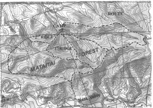
Map Reference: NZ 260-S11 Waiheke. ref 994654 (carpark). Note that the tracks have been altered and added to and may not be the same as shown on the map. A map can be obtained by contacting Manukau Tramping Club, PO Box 376, Papakura. The map shown here is a reproduction and may not be completely accurate in detail or scale. Each grid square is approximately 1 km.
Caveat: Not one of the walkways system. Crosses private land from the carpark. Please stay on the marked route. The track follows the fence line on the eastern and northern boundaries. Please do not cross the fence onto the private land. From the Ness Valley Road carpark, follow the marked route across the farmland and into the bush. The track climbs to the ridge top and there divides into a series of tracks giving access to the track network. The forest is typical regenerating broadleaf with stands of Tanekaha and Kauri. The newly cut track along the north eastern boundary has some large Puriri as well as stands of Kauri. This little forest treasure is one of the regions best kept secrets.
Back to Walkways Page
Alpine Sports Club inc. P.O. Box 131, Auckland, New Zealand. email email@alpinesport.org.nz